

17 April 2024
30 November 2022
Aerosols are solid or liquid particles suspended in the Earth’s atmosphere (e.g. dust, smoke, etc.) transported over short to large distances. This definition comprises various types of particles with different sources and shapes, as well as different physical properties and chemical compositions.
Atmospheric aerosols affect air quality, which in turn affect human health and the overall ecosystem. Because aerosols have direct and indirect radiative effects, they play an important role in the Earth’s radiation budget and consequently in the overall climate system. Aerosols are, therefore, very relevant to policy issues in both air quality and climate sciences.
In order to understand the role of aerosols in the atmosphere and in the overall climate system, observations of aerosol properties and of their spatiotemporal distribution and abundance are needed. Aerosol Optical Depth (AOD) — an indicator of scattering and absorption by aerosols — is one of the aerosol properties which is widely used by scientists to identify the amount of aerosol in the atmosphere.
Land-based observations can provide very accurate measurements of AOD and aerosol type in a certain location at a given time, but they are limited to specific locations. Satellite remote sensing is an excellent tool to describe and monitor the global distribution, transport and characteristics of the different aerosol types on a regular basis, which are important aspects needed for weather forecast, air quality and traffic monitoring, as well as policymakers and the scientific community.
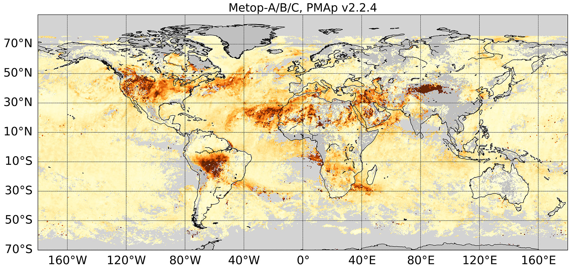
The Polar Multi-sensor Aerosol product (PMAp) product provides satellite-derived measurements of AOD (at 550nm) and other aerosol related parameters such as aerosol type over ocean and continents on a daily basis. PMAp was developed at EUMETSAT, and uses the operational infrastructures within the ground segment to retrieve the aerosol properties in Near Real Time (NRT, less than three hours after the sensing time).
PMAp is derived from a synergistic use of measurements from three Metop instruments: Global Ozone Monitoring Experiment (GOME-2), Advanced Very High-Resolution Radiometer (AVHRR), and Infrared Atmospheric Sounding Interferometer (IASI). The synergistic retrieval approach exploits the rich spectral (UV-TIR) content provided by the three sensors, the high spatial resolution of AVHRR, and the measurements of reflectance of GOME-2, which include polarisation.
The NRT satellite products are of great importance for operational users, such as the Copernicus Atmosphere Monitoring Service (CAMS), to analyse and assimilate air quality at the global scale and forecast it for the coming days. Currently the near real time forecast and reanalysis of aerosols using the ECMWF Integrated Forecasting System with atmospheric composition extension is constrained by the assimilation of the Moderate-resolution Imaging Spectroradiometer (MODIS) and PMAp AOD. For more details, see Monitoring multiple satellite AOD products within the CAMS data assimilation system. CAMS data are used extensively for high resolution insights into air quality problems, aircraft support and maintenance services, information on air quality and pollen, enabling individuals to monitor the air quality, etc.

The challenge of global aerosol retrieval and the motivation behind the synergy concept The global aerosol retrieval over land and ocean is challenging. Aerosol particles can be solid or liquid and can cover a wide range of particle sizes (0.005–100 µm), depending on aerosol type. This leads to very large variations in scattering and absorption characteristics. Additionally, the signal measured by the satellite is not only determined by the AOD of the aerosol. It is also sensitive to the surface properties and to the various aerosol optical properties like phase function and single scattering albedo. These parameters are connected to aerosol microphysics, characterized by particle size distribution, particle shape and refractive index. Additionally, usually more than one aerosol type with different scattering and absorption properties is present in an individual scene. Clouds (or residual cloud after filtering) might be present as well. To address this problem, it is necessary to use as much independent information as possible from different bands.
The synergy concept offers the possibility of increasing the amount of input information by combining measurements from different sensors. However, the combination of different instruments introduces new error sources caused by collocation, inter-calibration, different spectral response function etc., all of which must be considered in the design of retrieval algorithm.

Overview of the PMAp retrieval algorithm
The PMAp product is derived using a multi-sensor retrieval algorithm that retrieves globally the AOD at 550nm and related aerosol parameters (e.g., aerosol type) over ocean and continents. The AOD is retrieved at the spatial resolution of the GOME-2 Polarisation Measurement Devices (PMDs) on Metop: 10x40km2. The coarse spatial resolution of GOME-2 PMD and the relevant shortcomings (e.g. sub-pixel cloud detection) are compensated by exploiting the different spatial and spectral resolutions of the two additional sensors, AVHRR and IASI, to improve, complement and refine the retrieved information.
The retrieval algorithm includes three main steps:
- Cloud and aerosol discrimination, a pre-identification of the aerosol class, a cloud detection, and a cloud correction (decontamination when feasible).
- The retrieval of a set of AODs assuming the candidate aerosol types and microphysical properties from step 1.
- A selection of the AOD associated to the aerosol model showing the best fit to satellite measurements.
The synergy concept is mainly implemented in the first step, whereby the higher spatial resolution of AVHRR provides information about sub-pixel cloud coverage, the cloud correction allows the retrieval of AOD even for partially cloudy GOME-2 PMD pixels, and the use of the split-window technique informs about the dust/ash presence. The dust index calculated using IASI measurements plays a key role in identifying the scenes mainly dominated by dust aerosols. The GOME-2 UV index is applied to the retrieval of aerosol type over land, while AVHRR split-window informs about aerosol type over ocean. The fine structure of the IASI spectra is used to evaluate the chemical composition of aerosol detecting SO2 plumes and discriminating between dust and ash layers regardless of the underlying surface. In the second and third step, the polarised and unpolarised radiances measured by the GOME-2 PMDs are used to retrieve the aerosol optical properties directly.
The full description of the retrieval algorithm is provided in the PMAp paper.
This retrieval approach, besides a computationally efficient collocation algorithm, enables retrieving and delivering PMAp in near real time, which is a unique feature for a synergy product in the context of an operational service.
The final PMAp AOD product (a level 2 NRT product) is delivered at the following spatial resolution for PMAp Metop-B and C: 40km x 10km and swath width of 1920km (for Metop-A, it was 40km x 5km with a swath width of 96 km). In 2018, the combined product from the three-satellite constellation since the launch of Metop-C and before the stop of Metop-A allowed almost full global coverage of AOD measurements over land and ocean on a daily basis.
Processor version
The first version of operational PMAp was released in April 2014, which included only the retrieval over ocean. Two years later, the retrieval over land was added to the processor and a new version was released. After several updates, the last version was released in May 2021.
| Version | Status | Date – start of dissemination |
|---|---|---|
| Processor v1.0 | Operational over ocean/water bodies | 29 April 2014 |
| Processor v2.0 | Operational over ocean & demonstrational over land | 17 April 2016 |
| Processor v2.1 | Operational over ocean & demonstrational over land | 23 February 2017 |
| Processor v2.2 | Operational over ocean & demonstrational over land | 6 May 2021 |
Overview of the performance
The PMAp validation report provides a summary of validation activities conducted to quantify and assess the PMAp performance, and to inform the end-users about the quality of the data product including its strengths and known shortcomings.
The internal validation activities include the validation of PMAp against ground-based measurements of AERONET and the comparison of PMAp to other satellite-derived measurements of AOD such as MODIS/Terra Dark target and Deep blue Algorithms, the Suomi National Polar-orbiting Partnership (SNPP) Visible Infrared Imaging Radiometer Suite (VIIRS) NASA L2 product and the OSSAR-CS3 aerosol product from EUMETSAT retrieved from Sentinel-3 measurements.
The validation outcomes demonstrate the ability of PMAp to retrieve relevant AOD with a very good spatial and temporal behaviour and an acceptable overall performance. Despite the numerous differences between satellite AOD products, including the applied retrieval approaches, the sensors capabilities and limitations etc., the agreement between PMAp, VIIRS and S3 NRT data is already satisfactory.
The known limitations of PMAp are reported in the validation report as well as recommendations for users. Based on this, as well as feedback from users, PMAp is under a continuous process of improvement.
PMAp Climate Data Record (CDR)
PMAp has been reprocessed using the latest version of the retrieval algorithm (v2.2.4) to create a first version of a climate data record in the context of Copernicus Climate Change Service (C3S). The PMAp CDR is a combination of data retrieved from Metop-A and –B, and therefore covers 2007 to 2019. This dataset has been released in September 2022 and data is available via EUMETSAT User Helpdesk in two formats of Native and netCDF4. In addition to the user guide, a validation report is released to evaluate the quality of PMAp CDR.
