16 February 2023
08 July 2021
The aim of this study is the development, preliminary assessment, and implementation of a service to improve the scientific quality of the Copernicus Sentinel-3 SRAL/MWR Level-2 wet tropospheric correction (WTC), in order to achieve an altimeter height accuracy of about 1.4cm.
The estimation of accurate sea surface heights (SSH) from the Synthetic Aperture Radar Altimeter (SRAL) aboard Sentinel-3 requires the application of a number of corrections to the measured range, to account for the effects due to the atmosphere and the sea sate. Among these corrections, the WTC accounts for the effects due to water vapour and cloud liquid water, and is highly variable, both in space and time.
Objectives
The study covers the computation and assessment of the GPD+ WTC products for Copernicus Sentinel-3A (S3A) and Sentinel-3B (S3B), and includes the following steps.
- Computation of the GPD+ WTC for the latest S3 reprocessed dataset, baseline collection 004, consisting on about six years of data, from the start of mission until the end of April 2021.
- Delivery of the GPD+ WTC products to EUMETSAT.
- Assessment of the performance of the GPD+ WTC products.
- Assessment of the performance of the Altimeter 1D-VAR Tropospheric Correction (AMTROC).
- Use of the new AIRWAVE-SLSTR Level-2 Total Column Water Vapour (TCWV) test products to better characterise the water vapour (WV) variability in coastal areas, and compare the performances of the different products.
Overview
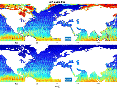
The improvement is accomplished by means of the GNSS (Global Navigation Satellite Systems) derived Path Delay Plus (GPD+) algorithm, developed at the University of Porto, to retrieve enhanced WTC for radar altimeter missions. This improvement is particularly relevant over surfaces where the WTC from the on-board MWR is not available or is invalid due to e.g. the presence of land or ice in the large MWR footprint, such as coastal zones, inland waters and polar regions.
The GPD+ are WTC estimated by space-time objective analysis, by combining all available observations in the vicinity of the point: valid measurements from the on-board microwave radiometer (MWR), from GNSS, and from scanning imaging MWR aboard various remote sensing missions. The requested improvement is relevant over surfaces where the WTC from the on-board MWR is not available or is invalid due to e.g. the presence of land or ice in the large MWR footprint, such as coastal zones, inland waters and high latitudes.


