

16 February 2023
07 April 2020
Hotspots are everywhere on Earth. The Copernicus Sentinel-3 (S3) FRP product, implemented by EUMETSAT, monitors in Near Real Time (NRT) the location and associated threat (i.e. total radiative power) of all land and ocean hotspots detectable on our planet.
Agricultural burning, wildfires, deforestation, tropical peatland fires, industrial gas flares, and volcanoes, all emit radiative signatures with a high seasonal and geographical variability. When uncontrolled, these events can have ravaging impacts on our global atmosphere, and those living in the vicinity.
In addition to its core marine and continental objectives, the Copernicus Sea and Land Surface Temperature Radiometer (SLSTR), onboard the Sentinel-3 A and B satellites, detects and monitors the immediate threats of any 'burning' events over an area size of 1 km2. Commonly gathered under the term of hotspots, these are not only fires over continents, but also flames from persistent land and ocean gas flares, and active erupting volcanoes. An example is given in Figure 1, showing SLSTR observations over the Australian bushfires on 5 December 2019.

Find out how to access the data
Objectives
The Copernicus NRT S3 FRP processor identifies the location, and quantifies the radiative power, of any hotspot present on land and ocean Earth surfaces, that radiates a heating signal within a pixel size of 1 km2. All threatening hotspots are identified and characterised in less than three hours since the SLSTR observation sensing time.
The current version of the NRT S3 FRP product is considered as 'preliminary operational'. It is mainly applicable during nighttime, while only a few daytime granules with non-saturated background (i.e. no fires) radiance, are processed at this stage. The NRT S3 FRP product will become operational after a higher level of quality and maturity is reached, including the full processing of granules during daytime, a comprehensive global validation, and positive feedback by experts and users.
Background
What are the common points between wildfires, industrial gas flares, and volcanoes?
They all are extremely warm: while Earth's average temperature is about 300 K, smouldering and intense flaming combustion exhibit temperatures in the range of 75–1200 K (Sullivan et al., 2013). Heating flames due to flammable gas disposed at the tip of a stack from Upstream Oil and Gas (UOG) industrial Gas Flaring (GF) can sometimes even heat up beyond 1500 K. Hence, they are commonly qualified as hotspots. Regardless of their location (land or ocean surfaces), their radiometric temperature leads to a heating spectral signal that can be seen from space. As temperature increases, the radiative emission peak moves towards shorter wavelengths. Consequently, vegetation fire signals peak in the Medium Wave InfraRed (MWIR), between 3 and 5 µm, while hotter bodies, like some GFs, may exhibit a higher signal in the ShortWave InfraRed (SWIR), between 1.5 and 2.3 µm.
Another commonality is their tremendous impacts on our environment. Fires are an important source of atmospheric trace gases and Black Carbon (BC) particles, which are harmful to human health and contribute to climate change. For example, observations from Metop satellites, our EUMETSAT Polar System (EPS), showed that large plumes of carbon monoxide (CO) and smoke released from the Australian bush fires between December 2019 and January 2020, travelled across the South Hemisphere.
Higher fire frequencies (e.g. deforestation, tropical peatland fires) increase the cumulative build-up of atmospheric carbon concentrations. Global average fire emission for the period 1997–2016, is estimated to be 2.2 Pg C yr−1, with substantial inter-annual variability. Net greenhouse gas emissions from all fires were on average six percent of global 2014 fossil fuel CO2 emissions, deforestation and tropical peat fires being the most dominant source (van der Werf et al., 2017).
Impacts on populations and land biomass can be devastating: e.g. 10 million hectares burnt in Australia in December 2019–January 2020, three times the size of Belgium (https://www.bbc.com/news/world-australia-50951043).
Similarly, GFs released between 2003 and 2012 ~304 Tg CO2 yearly, (Olivier et al., 2014), and 270 and 210 Gg of BC in 2005 and 2010, respectively (Klimont et al., 2017). Regionally, they contribute to half the near-surface BC concentration in the Arctic (Stohl et al., 2013).

Hotspots are everywhere (see Figure 2). Man-made fires occur on a regular basis in areas where agricultural burning traditionally occurs (e.g. Africa and Indonesia). Moreover, climate, land use, and other anthropogenic drivers have the potential to influence fire dynamics in many regions over the world: e.g. increased heatwave frequencies in many areas, such as Australia. Hence, it is vital to detect and monitor their location in NRT, and, in a timely manner, estimate their threat in order to support the protection of the population, our atmosphere, and the ecosystem. A globally consistent and independent survey is also necessary to reliably monitor GFs.
Monitoring our atmosphere - The Global Fire Assimilation System (GFAS)
Estimation of emissions from active fires by the Copernicus Atmosphere Monitoring Service (CAMS) is one of the key applications of the Copernicus NRT S3 FRP product. To understand the immediate and long-term impact of active fires on our Earth’s atmosphere, carbon cycle, and air quality, aerosol and gas emissions must be computed. CAMS, implemented by the European Centre for Medium-Range Weather Forecasts (ECMWF) on behalf of the European Commission, will use its Global Fire Assimilation System (GFAS) to assimilate the NRT Copernicus S3 FRP product, in addition to currently assimilated satellite FRP products, in order to provide global biomass burning smoke emissions in a timely and effective manner. Currently, GFAS assimilates FRP from MODIS space-borne sensors, from both Terra (morning) and Aqua (afternoon) satellites. Both have been operated beyond their nominal lifetime. Hence, GFAS is currently under preparation to be able to ingest the NRT S3 FRP product soon. In the future, NRT S3 FRP, combined with GFAS, will likely be the only source of global information for fires and hotspots in the early morning and evening.
Overview of the algorithm
Processor version
The core algorithm lying behind the Copernicus NRT S3 FRP product was designed by Professor Dr Martin Wooster and Dr Weidong Xu at Kings College London (KCL) and the National Centre for Earth Observation (NCEO). It performs both 'active hotspot detection and 'radiative power quantification at 1 km resolution. FRP is related to the rate at which combustible is being consumed per unit of time as a direct result of the combustion process. The disseminated NRT FRP granules are of five-min duration.
The EUMETSAT deployment is based on the NRT FRP v2.0 processor. The starting point of this processor was the v1.3 originally developed by ACRI-ST, in the framework of the ESA Sentinel-3 Mission Performance Center contract. Both ESA and EUMETSAT followed the algorithm development. The v2.0 processor additionally includes several EUMETSAT in-house developments specific to this NRT FRP processor.
| Version | Status/Date |
|---|---|
| Processor V2.0 – Product Baseline Collection 1 | Deployed on OPE on 08/04/2020. Available on ODA since 08/04/2020. Available on EUMETCAST, UMARF since 21/04/2020. |
| Processor V1.3 | Delivered to EUMETSAT on 14/02/2020. Internal. |
Assets of the processor
The assets of the v2.0 processor are the following:
- The latest NRT SLSTR Level 1B (L1B) Processing Baseline (PB), 2.59 (A) & 1.31 (B), operationally deployed on 15 January 2019, is a pre-requisite input.
- Cloud mask tests are internal to the FRP processor, i.e. not taken from those available in the SLSTR L1B data. The same applies for the Land/Sea mask which comes from the Global Land Cover (GLC) 2000.
- Four essential SLSTR channels are used: S5 (SWIR – 1.6 µm), S6 (SWIR - 2.25 µm), the two S7 & F1 (MWIR – 3.7 µm), and S8 (TIR – 10.8 µm).
- F1 & S7 differ in terms of dynamic range. F1, called the 'hot' channel, doesn't saturate over hot fires, but may be noisier. In contrast, S7 is less noisy, but becomes highly uncertain above 305 K, and even saturates ~313 K.
- Consequently, scenes with S7 saturated background (i.e. non impacted by hotspots) are not processed for now. This essentially occurs during daytime. Note that scenes where only hotspot pixels are saturated in S7 are processed, thanks to the F1 detector.
- Two types of hot spots are identified:
- 'FRP MWIR', based on 3.7 µm, for warm hotspots with T > 600 K, e.g. vegetation fires – Applicable by day global, by night only over land surfaces (see Figure 2).
- 'FRP SWIR', based on 2.25 µm, for very warm hotspots with T > 1000 K, e.g. gas flares, – Applicable by night global, and by day only for ocean gas flares (see Figure 3).
- Both hotspot types are relevant and shall be considered by users. Some events will be detected by one of the two tests, others will be by both (but only counted once in the overall total number of fires per granule). But the warmer FRP shall be considered as the most reliable.
- A tuning has been done to minimise SWIR false alarms due to solar irradiance residuals in the northern latitudes, from end of autumn to end of winter in twilight conditions.
- Additionally, the channel S5 (1.6 µm) is used by night to improve the reliability of very warm FRP SWIR.
- A specific flag is added to filter out South Atlantic Anomalies (SAA) and other transient or spurious events, during the night. Users interested by FRP SWIR are strongly advised to use 'FLAG_SWIR_SAA' equal to the value of 0 to optimise their focus on real hotspots, such as fires in Argentina, Bolivia, and others (see Figures 3 & 4).

- A series of flags, indicating the outcome of each single detection test, is reported for all original L1 pixels on the S7 image grid (1 km). This allows advanced users to investigate potential omitted events.
- Additional parameters are provided for each detected hotspot, such as FRP uncertainty, radiance value (S6, S7, and/or F1), transmittance corrected from H2O absorption, potential hotspot type.

- As depicted in Figures 5 and 6, detection of gas flares & other very warm fires, 'outshining' by night, are further optimised thanks to a better discrimination of the S6 radiometric signal and high occurrence of S6 background noise in the absence of Sun irradiance.


- Heating signals from equatorial warm waters are discriminated from real hotspots.
Current reference processor configuration exclusively computes FRP MWIR, after detection, as follow:
- for S7 non saturated hot spot pixel: use of S7 radiance
- for S7 saturated hot spot pixels: use of F1 radiance
A clustering image correlation technique allows the mapping of consistent F1 and S7 hotspots onto each other. This technique is, hereafter, named 'Full F1 Off'.
Overview of the performance
Evaluation status
A complete validation is ongoing by EUMETSAT, in collaboration with CAMS and the GFAS developers. This also includes: extending the reference validation frame of the EUMETSAT Meteosat Second Generation (MSG) Fire detection over Central Africa to the S3 FRP, together with computation of key statistic metrics for commission and false alarm ratios, and FRP satellite inter-comparisons of both near-simultaneous and gridded observations. The preliminary evaluation below will be regularly updated on this page and in a much more detailed public validation report.
Preliminary qualitative evaluation results focused on night time SLSTR-A and B show the following:
- Most of industrial gas flares in the Persian Gulf, Algeria, and the North Sea areas are frequently well detected, by both SWIR and MWIR tests. It is expected that FRP SWIR better captures hotter flames, while those at medium temperatures shall be commonly found between FRP SWIR and MWIR. Accuracy of FRP detection and estimations is being assessed.
- Deforestation, tropical peats, savannah and other vegetation fires are, overall, well detected by MWIR tests in South America, Central Africa, India, Thailand, Indonesia, and Australia areas.
- Hotspot detection from SLSTR seems to be lower than 10 MW, perhaps even below 5 MW (awaiting confirmation).
Quantitatively — night time:
SLSTR-A 1 km hotspots FRP statistics for the whole month of December 2019:
- Hotspots identified by MWIR
- Hotspots identified by SWIR
- Hotspots identified by both MWIR and SWIR
- Hotspots flagged as transient events by and removed with FLAG_SWIR_SAA = 0
| 1 km hotspots | Detected by MWIR | Detected by SWIR | Detected by MWIR and SWIR | Removed by SAA flag |
|---|---|---|---|---|
| Worldwide | 71.1% | 57.7% | 28.8% | 15.1% |
| Australia | 89.6% | 46.3% | 35.9% | 9.3% |
| Persian Gulf | 72.3% | 56.0% | 28.0% | 2.2% |
SLSTR-A FRP temporally & spatially integrated at 1 deg (IFRP) statistics for the whole month of December 2019:
| 1 deg (IFRP) | MWIR/SWIR correlation | Higher IFRP | Dominant Fire types |
|---|---|---|---|
| Australia | R2=0.97 | MWIR > SWIR by 1070.2 MW | vegetation fires |
| Persian Gulf | R2=0.99 | SWIR > MWIR by 468.3 MW | extremely warm flaming industries |
Satellite inter-comparisons
- No major differences were observed between SLSTR-A and -B.
- SLSTR-A vs. MODIS Terra:
- On a daily basis, a higher number of 1 km hot spots, with low FRP MWIR values (i.e. smaller than 10 MW) are detected by SLSTR. This remains to be confirmed, but it is firstly assumed to be related to less conservative thresholds applied in the NRT S3 FRP processor. Hence, SLSTR FRP may better capture lower radiative hot spots, that are overall more often occurring on Earth than bigger ones.
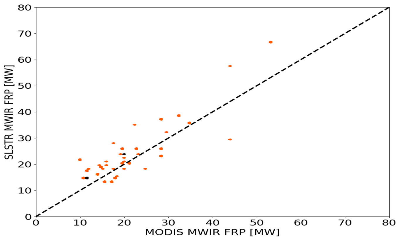
- Over the full month of December 2019, spatio-temporal Average FRP (AFRP) MWIR at 2 deg between SLSTR-A and MODIS Terra are compared by considering only individual SLSTR-A and MODIS FRP > 10 MW (MODIS threshold detectability) and MODIS pixels not affected by the 'bow-tie' effects: regional correlation is reasonable (R2 = 0.55 over Australia continent, 0.74 over Persian Gulf gas flares – see Figure 7); Average AFRP differences are low: 1.18 MW ± 21.5 MW (worldwide), -5 MW ± 26.8 MW (Australia continent), and 2.74 ± 11.0 MW (Persian Gulf gas flares).
Known limitations
Specific challenges are under verification, such as scenes with many fires spatially close to each other, coastal areas, detectability performance for low hot spot signal, geometry and L1B gridding impacts, cloud mask v heavy smoke load.
Furthermore, the NRT S3 FRP is expected to have some direct limitations due to known SLSTR L1B issues, especially:
- S5 and S6 radiometric channels have known mis-calibration issues. A vicarious calibration assessment is undergoing to refine values and estimate uncertainties. At this stage, a limited impact on the SWIR detection is expected, this can affect both FRP estimation and SAA filtering.
- Some twilight residuals in FRP SWIR have been detected in the northern Arctic Sea, starting just after the spring equinox (first time observed on 24.03.2020). Resulting false alarms are, for now, minor and under strict monitoring. They are not expected to overlap with actual detection of ocean gas flares in the North Sea, and close to the southern Norwegian coasts. Hence, associated FRP SWIR in these areas can be considered as reliable. These twilight residuals will be corrected soon in the next upgrade of the NRT processor deployment.
- Contrary to F1, no BT beyond 313 K can be obtained from S7 because of saturation. Furthermore, all S7 BTs above 305 K are known to present non-linear behaviour as the values are beyond the nominal limits of the detector and related radiometric calibration performance.
- BTs from F1 are expected to be noisier than those from S7.
- S7 and F1 are acquired by two different detectors. Detection of hotspots is very sensitive to the residual mis-registration of these two bands. Although much improved in the latest upgrade of the L1B PB, this geo-referencing is not yet perfect with a remaining average spatial off-set of 1 km. This residual error is mitigated by the use of a S7-F1 clustering technique.
- S7 and F1 show different deformation of pixel between nadir and the left edge when projected on the Earth (factor ~5.4 for S7 while it is close to 2 for F1). Consequently, S7 may oversample hot-spots (as observed for the MODIS 'bow-tie' effect, see Giglio et al., 2013).
To tackle the latest item, a possibility of exclusively using F1 radiance over all S7 hotspot pixels (regardless of their saturation status) is implemented in the processor. This technique, named 'Full F1 On', is currently under evaluation, based on a full off-line reprocessing of SLSTR-A and B data from 1 December 2019 onwards.
Additional activities are ongoing to enhance the characterisation of geometry-FRP effects and consolidation of SAA and transient/spurious SWIR event filtering. Additionally, optimised processor code rewriting is expected to improve the processing of very low hotspot signals.
Finally, specific FRP pixels are under investigation to better understand the exact mechanisms triggering these positive detections. These include few, but systematic, FRP MWIR pixels appearing in Siberia, plus a very small number of spurious pixels in western Europe and western Canada in winter and spring. The first one may be caused by local hot bodies (plants or others) surrounding by wide frozen surfaces, leading to a locally very strong thermal gradient (to be confirmed).
Recommendations for users
Users are advised to consider the key assets and possible limitations from above, together with the fact that the current version of the NRT Copernicus S3 FRP product is preliminary operational. Users should use the 'Fire_Confidence' value with caution, as it is systematically too low, being based on S7 instead of F1 BT. An upgrade is expected in the future.
The ancillary dataset can be used for extracting the location associated with the summary fire flags indicating the detection test per original S7 pixel grid.
Night-time boundary may be deduced in two ways: either from the fire summary flags in the FRP_in.nc file, or from the solar geometry available in the ancillary FRP dataset.
Monitoring of NRT S3 FRP performance can be followed on the Monitoring & Evaluation of Thematic Information from Space (METIS) FRP website.

